Tropical disturbance update
Published 9:09 am Thursday, August 26, 2021
|
Getting your Trinity Audio player ready...
|
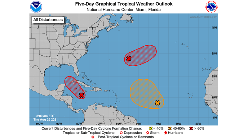
This morning a broad area of low pressure is located over the west-central Caribbean Sea about 150 miles south-southwest of Jamaica. The associated showers and thunderstorms continue to show signs of organization and environmental conditions remain conducive for additional development. A tropical depression or tropical storm is expected to form later today or tonight while the system moves northwestward over the northwestern Caribbean Sea, reaching the Cayman Islands tonight and western Cuba and the Yucatan Channel Friday and Friday night. It has a high (90 percent) chance of formation during the next 48 hours and five days Given the recent developmental trends, Tropical Storm Warnings for the Cayman Islands and western Cuba could be required later this morning, and an Air Force Reserve reconnaissance aircraft is scheduled to investigate the system this afternoon. Regardless of development, locally heavy rainfall and flooding are possible over portions of Jamaica and the Cayman Islands today and tonight, and will likely spread across Cuba and the Yucatan Peninsula on Friday.
The system is expected to enter into the Gulf of Mexico Friday night and continue moving northwestward toward the central or northwestern U.S. Gulf coast, potentially bringing dangerous impacts from storm surge, wind, and heavy rainfall to portions of the coasts of Texas, Louisiana, Mississippi, Alabama, and the Florida Panhandle by Sunday and Monday. However, uncertainty in the system’s exact track and intensity remains large since the low is just beginning to form. Interests in these areas should closely monitor the progress of this system and ensure they have their hurricane plans in place. Additional information on this system, including gale warnings, can be found in High Seas Forecasts issued by the National Weather Service at ocean.weather.gov/shtml/NFDHSFAT1.php
Elsewhere over the Atlantic basin, a trough of low pressure is located over the central Atlantic about 600 miles east of Bermuda continues to produce disorganized showers and thunderstorms. Environmental conditions are forecast to be generally conducive for development, and a tropical depression is likely to form late this week or this weekend while the system moves slowly eastward at 5 to 10 mph. It has a medium (40 percent) chance of formation during the next 48 hours and a medium (60 percent) chance during the next five days.
Another tropical wave is located over the central tropical Atlantic about 1000 miles west-southwest of the Cabo Verde Islands, producing disorganized showers and thunderstorms. Environmental conditions appear a little more conducive for development during the next few days, and a tropical depression could form by the weekend while the system moves toward the west-northwest or northwest at 10 to 15 mph. Upper-level winds could become less conducive for development by early next week. It has a medium (40 percent) chance of formation during the next 48 hours and a medium (50 percent) chance during the next five days. www.hurricanes.gov