Tornado Watch issued for St. John Parish
Published 9:16 am Monday, April 27, 2015
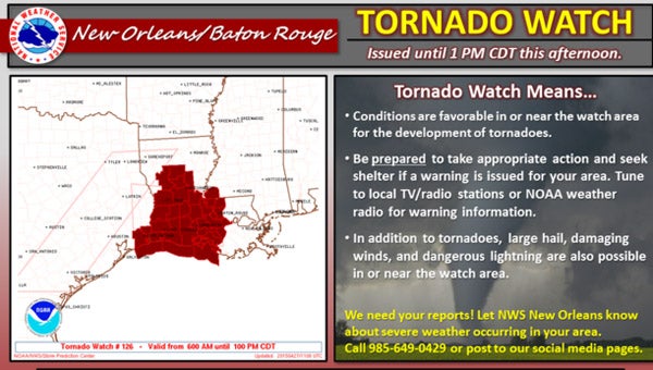
- The National Weather Service has issued a tornado watch for St. John the Baptist Parish and other portions of south-central Louisiana until 1 p.m. today (April 27).
LAPLACE — The National Weather Service has issued a tornado watch for St. John the Baptist Parish and other portions of south-central Louisiana until 1 p.m. today (April 27).
St. John is currently under a Flash Flood Watch until 1 p.m. Tuesday. A strong storm system will be moving through the area bringing the risk of heavy rain, large hail, damaging winds and possible isolated tornadoes.
Due to power outages, Garyville-Mt. Airy Math and Science Magnet School, the St. John Child Development Center and West St. John High School will dismiss early at 1:15 p.m. West St. John Elementary School will dismiss at 1:30 p.m. Parents are asked to make arrangements accordingly.
Please use caution when venturing outdoors and operating vehicles in the severe weather. Please report any issues or concerns during the weather event to 9-1-1. Should a tornado warning being issued, seek shelter immediately, pull off roadways, and cover your head.
Public Works and Utilities crews are on standby in the event issues arise with drainage and utility systems. Dial 9-1-1 to report any emergencies including drainage issues and street flooding.
The St. John the Baptist Parish Office of Emergency Preparedness and Communications Office are in contact with the National Weather Service to receive the latest weather updates and forecasts. Sign up to receive emergency notifications to your home phone, cell phone, email or SMS text messaging device by visiting the homepage of the Parish’s website at sjbparish.com and clicking on “Stay Connected.”
Impacts/Precautions:
Severe Thunderstorms
Take shelter! Move to a sturdy building or car.
• Avoid tall structures such as towers, tall trees, fences, telephone lines or power lines.
• Stay away from rivers, lakes or other bodies of water.
• You are in danger of lightening if you can hear thunder.
• Pets should be protected or moved indoors.
Strong Wind
• Damaging wind gust in excess of 60 mph which could down trees and power lines and/or cause structural damages.
• Winds this strong can make driving difficult, especially for high profile vehicles and high rise bridges. Use extra caution.
• Winds over local waterways could be 5 mph higher than over land. Small boats will be especially prone to capsizing.
Isolated Tornadoes
• If you receive a tornado warning, protect yourself, your family and your pets; seek shelter immediately.
• Turn off all sources of outside air: air conditioner, ventilation vents, and ducts.
• If you are in a car and cannot get to adequate shelter, STOP! Get out and lie flat in a low lying area such as a ditch or ravine. Cover your head!