Friday morning update on Ida: Residents urged to finalize plans
Published 7:58 am Friday, August 27, 2021
|
Getting your Trinity Audio player ready...
|
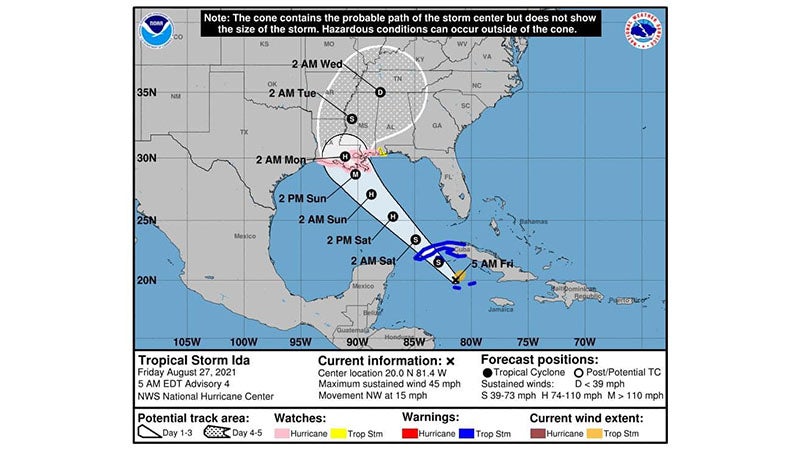
ST. JOHN THE BAPTIST PARISH — Hurricane and storm surge watches are in effect in advance of Ida, which is anticipated to bring hurricane force winds to the St. John the Baptist Parish area beginning on Sunday and going into Monday.
The 7 a.m. advisory forecasts Ida to strike Louisiana as a Category 3 major hurricane with wind speeds of 115 miles per hour.
Possible impacts include heavy rainfall, damaging winds, storm surge and tornadoes with landfall forecast for Sunday along the Louisiana Coast. Residents are urged to finalize hurricane plans today. Preparations include gathering supplies, stocking emergency supply kits, clearing storm drains, securing homes/yards, making preparations for pets and checking on elderly neighbors.
This morning’s advisory from the National Hurricane Center stated that tropical storm conditions are currently occurring in portions of the Cayman Islands.
There is an increasing risk of life-threatening storm surge along the coasts of Louisiana, Mississippi and Alabama. The National Hurricane Center also warned of an increasing risk of dangerous hurricane force winds beginning Sunday along portions of the coasts of Louisiana and Mississippi.
Heavy rainfall is anticipated across the central Gulf Coast from Sunday into Monday, which could result in flash flooding.
Stay informed and sign up for weather alerts (text SJPWEATHER to 888-777).