| Since 2004, the Louisiana Department of Wildlife and Fisheries (LDWF) has successfully removed and disposed of over 50,000 abandoned and derelict crab traps together with individual volunteers and organizations. The removal of these crab traps is critical to boating safety and crab harvesting efforts. Due to Covid-19, LDWF did not host any volunteer events during the 2021 cleanup efforts. Although we were not able to work alongside members of the recreational and commercial fishing industries during our derelict crab trap removal efforts last year, LDWF and the Pontchartrain Conservancy teamed up to remove more than 5,150 derelict or abandoned crab traps.
LDWF is committed to working tirelessly toward reducing derelict crab traps across coastal Louisiana and will look to the recreational and commercial sectors for assistance in the 2022 cleanup efforts. LDWF plans to host multiple volunteer events in 2022. Those interested in participating should monitor our website and news releases for additional information.
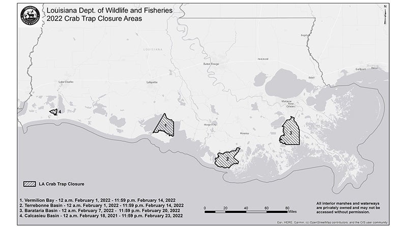
At today’s meeting, the LWFC adopted a Notice of Intent (NOI) allowing the removal of derelict crab traps along Louisiana’s coast in 2022 from the four following described areas:
- The first closure will take place in the Terrebonne Basin, in an area southwest of Dularge, from 12 a.m. Tuesday, February 1, 2022, through 11:59 p.m. Monday, February 14, 2022.
- The second closure will take place in the Vermilion Basin, in an area between the Acadiana Navigational Channel and East Cote Blanche Bay, from 12 a.m. Tuesday, February 1, 2022, through 11:59 p.m. Monday, February 14, 2022.
- The third closure will take place in the Barataria Basin, in an area south of Lafitte, from 12 a.m. Monday, February 7, 2022, through 11:59 p.m. Sunday, February 20, 2022.
- The fourth closure will take place in the Calcasieu Basin, in the West Cove portion of Calcasieu Lake, from 12 a.m. Friday, February 18, 2022, through 11:59 p.m. Wednesday, February 23, 2022.
1. Terrebonne Basin Crab Trap Removal
The use of crab traps shall be prohibited for a 14-day period from 12:00 a.m. February 1, 2022 through 11:59 p.m. February 14, 2022:
- From a point originating at the intersection of the eastern shoreline of Bayou Dularge and the southern shoreline of Falgout Canal (29 degrees 24 minutes 42.57 seconds north latitude, 90 degrees 46 minutes 59.40 seconds west longitude); thence westerly along the southern shoreline of Falgout Canal to its intersection with Lake de Cade (29 degrees 24 minutes 51.57 seconds north latitude, 90 degrees 49 minutes 55.05 seconds west longitude); thence southwesterly along the eastern and southern shorelines of Lake de Cade to the northern shoreline of Bayou de Cade; thence southwesterly along the northern shoreline of Bayou de Cade to its intersection with Lost Lake; thence westerly and southerly along the northern and western shorelines of Lost Lake to its intersection with the western shoreline of Rice Bayou; thence southerly along the western shoreline of Rice Bayou to its intersection with Blue Hammock Bayou (29 degrees 18 minutes 19.26 seconds north latitude, 91 degrees 05 minutes 05.33 seconds west longitude); thence westerly along the northern shore of Blue Hammock Bayou to Four League Bay (29 degrees 17 minutes 43.49 seconds north latitude, 91 degrees 07 minutes 26.81 seconds west longitude); thence southerly along the eastern shoreline of Four League Bay to the mouth of Oyster Bayou; thence southerly along the eastern shoreline of Oyster Bayou to a point along the inside-outside shrimp line as defined in LAC 76:VII.370 (29 degrees 13 minutes 17.52 seconds north latitude, 91 degrees 07 minutes 45.76 seconds west longitude); thence easterly along the inside-outside shrimp line to the eastern shoreline of Bayou Grand Caillou; thence northerly along the eastern shoreline of Bayou Grand Caillou to its intersection with the southern shoreline of the Tennessee Gas Pipeline (29 degrees 14 minutes 56.52 seconds north latitude, 90 degrees 48 minutes 17.97 seconds west longitude); thence northwesterly across Bayou Grand Caillou to the western shoreline of Bayou Grand Caillou (29 degrees 15 minutes 4.23 seconds north latitude, 90 degrees 48 minutes 27.57 seconds west longitude); thence northerly to the northern shoreline of the Tennessee Gas Pipeline canal (29 degrees 15 minutes 5.55 seconds north latitude, 90 degrees 48 minutes 26.46 seconds west longitude); thence northwesterly along the northern shoreline of the Tennessee Gas Pipeline canal to the eastern shore of Bayou Dularge (29 degrees 17 minutes 48.98 seconds north latitude, 90 degrees 52 minutes 23.57 seconds west longitude); thence northerly along the eastern shoreline of Bayou Dularge and terminating at its origin.
2. Vermilion Basin Crab Trap Removal
The use of crab traps shall be prohibited for a 14-day period from 12:00 a.m. February 1, 2022 through 11:59 p.m. February 14, 2022:
- From a point originating on the northern shoreline of the Gulf Intracoastal Waterway where it intersects the Acadiana Navigational Channel (29 degrees 50 minutes 37.17 seconds north latitude, 91 degrees 50 minutes 32.40 seconds west longitude); thence to a point on the southern shoreline of the Gulf Intracoastal Waterway (29 degrees 50 minutes 28.22 seconds north latitude, 91 degrees 50 minutes 35.30 seconds west longitude); thence southwesterly along the Acadiana Navigational Channel red buoy line to the red navigational marker number 12 on the Marsh Island shoreline near Southwest Pass (29 degrees 36 minutes 10.81 seconds north latitude, 92 degrees 00 minutes 17.16 seconds west longitude); thence easterly along the northern shoreline of Marsh Island to 29 degrees 33 minutes 51.30 seconds north latitude, 91 degrees 43 minutes 00 seconds west longitude; thence north along 91 degrees 43 minutes 00 seconds west longitude to the northern shoreline of West Cote Blanche Bay (29 degrees 44 minutes 21.17 seconds north latitude, 91 degrees 43 minutes 00 seconds west longitude); thence westerly along the northern shoreline of West Cote Blanche Bay to its intersection with the Ivanhoe Canal (29 degrees 45 minutes 03.58 seconds north latitude, 91 degrees 44 minutes 15.16 seconds west longitude); thence northerly along the eastern shoreline of the Ivanhoe Canal to its intersection with the Gulf Intracoastal Waterway (29 degrees 45 minutes 45.92 seconds north latitude, 91 degrees 44 minutes 20.76 seconds west longitude); thence north to the northern shoreline of the Gulf Intracoastal Waterway (29 degrees 45 minutes 52.14 seconds north latitude, 91 degrees 44 minutes 23.78 seconds west longitude); thence westerly along the northern shoreline of the Gulf Intracoastal Waterway and terminating at the origin.
3. Barataria Basin Crab Trap Removal
The use of crab traps shall be prohibited for a 14-day period from 12:00 a.m. February 7, 2022 through 11:59 p.m. February 20, 2022:
- From a point originating at the intersection of the Gulf Intracoastal Waterway and the northern shore of Hero Canal (29 degrees 48 minutes 12.73 seconds north latitude, 90 degrees 04 minutes 09.21 seconds west longitude); thence westerly to a point along the western shore of the Gulf Intracoastal Waterway at 29 degrees 48 minutes 15.14 seconds north latitude, 90 degrees 04 minutes 18.67 seconds west longitude; thence southerly along the western shore of the Gulf Intracoastal Waterway to a point opposite the western shore of Bayou Perot (29 degrees 40 minutes 56.67 seconds north latitude, 90 degrees 11 minutes 36.79 seconds west longitude); thence easterly to a point on the western shore of Bayou Perot at 29 degrees 40 minutes 50.66 seconds north latitude, 90 degrees 11 minutes 25.48 seconds west longitude; thence southerly along the western shore of Bayou Perot and Little Lake to Bay L’Ours; thence westerly and southerly around the shoreline of Bay L’Ours to Brusle Lake; thence southerly and easterly following the shoreline of Brusle Lake to a point on the southern shoreline of Bayou De Chene at 29 degrees 29 minutes 14.83 seconds north latitude, 90 degrees 12 minutes 02.02 seconds west longitude; thence easterly along the southern shoreline of Bayou De Chene to Round Lake (29 degrees 29 minutes 10.15 seconds north latitude, 90 degrees 11 minutes 38.40 seconds west longitude); thence southerly and easterly along the shoreline of Round Lake to a point on the western shoreline of East Fork Bayou L’Ours (29 degrees 28 minutes 52.30 seconds north latitude, 90 degrees 09 minutes 32.60 seconds west longitude); thence southerly along the western shoreline of East Fork Bayou L’Ours to a point at 29 degrees 27 minutes 35.00 seconds north latitude, 90 degrees 08 minutes 48.23 seconds west longitude; thence eastward along 29 degrees 27 minutes 35.00 seconds north latitude to the eastern shore of Wilkinson Canal (29 degrees 27 minutes 35.00 seconds north latitude, 89 degrees 57 minutes 04.11 seconds west longitude); thence northerly along the eastern shore of Wilkinson Canal to its termination; thence northerly to the western shore of the Mississippi River at 29 degrees 38 minutes 24.94 seconds north latitude, 89 degrees 57 minutes 01.21 seconds west longitude; thence northerly along the western shore of the Mississippi River to a point easterly of the northern shoreline of Hero Canal (29 degrees 47 minutes 09.60 seconds north latitude, 90 degrees 01 minutes 17.77 seconds west longitude); thence westerly to the northern shore of Hero Canal; thence westerly along the northern shore of Hero Canal and terminating at the origin.
4. Calcasieu Basin Crab Trap Removal
The use of crab traps shall be prohibited for a 14-day period from 12:00 a.m. February 18, 2022 through 11:59 p.m. February 23, 2022:
- From a point located where the north bound lane of Highway 27 intersects the northern shoreline of West Cove Canal at 29 degrees 52 minutes 00.52 seconds north latitude, 93 degrees 27 minutes 13.66 seconds west longitude; thence southwesterly along the north bound lane of Highway 27 to its intersection with the southern shoreline of West Cove Canal (29 degrees 52 minutes 00.17 seconds north latitude, 93 degrees 27 minutes 14.29 seconds west longitude); thence southeasterly along the southern shoreline of West Cove Canal to its intersection with the Calcasieu Lake – West Cove (henceforth known as West Cove) at 29 minutes 51 degrees 44.10 seconds north latitude, 93 degrees 26 minutes 36.26 seconds west longitude; thence southeasterly following the western and southern shorelines of West Cove to its intersection with the southern shoreline of the Calcasieu Pass West Fork (29 degrees 49 minutes 54.53 seconds north latitude, 93 degrees 23 minutes 15.81 seconds west longitude); thence southerly and easterly along southern shoreline of the Calcasieu Pass West Fork to its intersection with the Calcasieu Lake Ship Channel (29 degrees 49 minutes 13.82 seconds north latitude, 93 degrees 21 minutes 01.03 seconds west longitude); thence northerly to a point on the northern shoreline of the Calcasieu Lake West Fork (29 degrees 49 minutes 27.26 seconds north latitude, 93 degrees 20 minutes 59.79 seconds west longitude); thence northwesterly along the northern shoreline of the Calcasieu Lake West Fork to its intersection with West Cove (29 degrees 49 minutes 45.45 seconds north latitude, 93 degrees 22 minutes 56.75 seconds west longitude); thence easterly along the southern shoreline of West Cove to the eastern shoreline of West Cove; thence northerly along the eastern shoreline of West Cove to the northern shoreline of West Cove; thence westerly and southerly along the northern and western shorelines of West Cove to its intersection with the northern shoreline of West Cove Canal (29 degrees 51 minutes 46.11 seconds north latitude, 93 degrees 26 minutes 35.43 seconds west longitude); thence northwesterly along the northern shoreline of West Cove Canal and terminating at the origin.
All crab traps remaining in the closed area during the specified period will be considered abandoned.
In the weeks leading up to the closure, LDWF will mail notices to all commercial crab trap license holders and crab buyers within the affected parishes as well as non-resident licensed crab fishermen who landed blue crab within the previous year from Louisiana waters.
These proposed trap removal regulations do not provide authorization for access to private property. Authorization to access private property can only be provided by individual landowners.
Crab traps may be removed only between one half-hour before sunrise to one-half hour after sunset. Only LDWF or those designated by LDWF will be authorized to remove derelict crab traps in the closure areas. Abandoned traps must be brought to LDWF designated disposal sites and may not be taken from the closed area unless otherwise specified by the LWFC.
Please click here to view maps of the designated closure areas
Interested persons may submit written comments relative to the proposed rule to Peyton Cagle, Marine Fisheries Biologist DCL-B, Marine Fisheries Section, 1213 N. Lakeshore Dr., Lake Charles, LA 70601, or via e-mail to: pcagle@wlf.la.gov prior to October 5, 2022. |