Elevated levee alignment would offer flood protection in Barataria Basin
Published 12:00 am Saturday, January 16, 2021
|
Getting your Trinity Audio player ready...
|
LULING — The U.S. Corps of Engineers recently held a public meeting on the Upper Barataria Feasibility Study, which seeks to reduce flooding impacts to the Upper Barataria Basin stretching from Luling to Raceland.
This will likely involve a $1.9 billion levee alignment spanning more than 30 miles and elevated to 16 to 18.5 feet. An additional 12.3 miles of improvements to the existing St. Charles Parish levee are also planned to reduce flood risk.
Project manager Danielle Keller said the current study is about two years into a three-year process, and it will reach completion with the signing of a chief’s report in October 2021. Public meetings have been held since 2018 to keep communication open.
To create or start a project, the Corps needs authority from Congress and appropriations or funding. Authority was given back in May 1998, while funding came through the Bipartisan Act of 2018.
The Coastal Protection and Restoration Authority provides support and stakeholder management as the non-federal sponsor for this project.
“This study is fully federally funded, and we are held to a $3 million budget by Congress,” Keller said.
Congress is also holding the project to a timeline of three years, with three levels of vertical integration. This means the U.S. Army Corps of Engineers New Orleans District stays in contact with an office in Vicksburg, Mississippi, while the office in Mississippi communicates with Washington D.C.
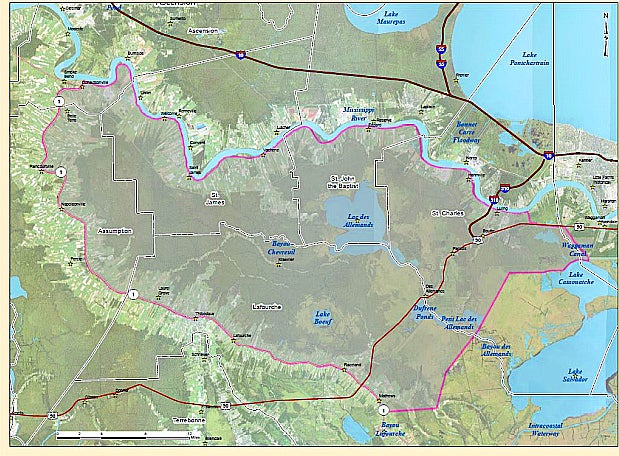
When the feasibility study began, a number of options were explored to determine the best way to manage the flood risk within the study area, which includes the communities of Ascension, Assumption, Jefferson, Lafourche, St. Charles, St. James and St. John the Baptist parishes.
The 800-square mile study area is bordered by the Mississippi River Levee to the north and Bayou Lafourche to the south, extending from Donaldsonville to just past U.S. Highway 90.
Dr. Matthew Boland, lead plan formulator for the Upper Barataria study, said there have been several changes to the draft report within the past year.
The initial chosen plan was a 7.5-foot tall, 18.3-mile levee system. According to Boland, it was later determined that 7.5 feet would not be sufficient to withstand overtopping.
“The levee elevations had to be increased significantly. The existing St. Charles levee also had to be elevated to reduce the risk of flooding and to address deficiencies along the existing system,” Boland said.
The Draft 2 tentatively elected plan proposes a $1.9 billion, 16 to 18.5 feet elevation levee alignment stretching about 36 miles in length. The levee alignment is expected to start in Luling, where it will connect to the Mississippi River Levee, continuing south with updates to the existing levee in St. Charles Parish. According to the draft, this alignment would then cross Bayou Des Allemands with a 270-foot barge gauge structure and continue parallel to U.S. Highway 90 before reaching the high ground near Raceland.
Keller said the study will be submitted to the Mississippi office in March 2021. In April 2021, it will be submitted to headquarters for several months of Washington level reviews. A Chief’s report will be signed and returned to the regional integration team later this year.
The public can send comments by Jan. 25 to UpperBaratariaFS@usace.army.mil or mvnenvironmental@usace.army.mil or mail written comments to the U.S. Corps of Engineers New Orleans District:
CEMVN-PMR
7400 Leake Avenue
Room 331
New Orleans, LA 70118
Copies of the presentation will be posted to the project website, www.mvn.usace.army.mil/About/Projects/BBA-2018/studies/Upper-Barataria-Louisiana/
Videos of meetings will be posted on the U.S. Army Corps of Engineers New Orleans District’s YouTube page.