Bonnet Carre Spillway constructed after Great Flood of 1927
Published 12:12 am Saturday, January 30, 2016
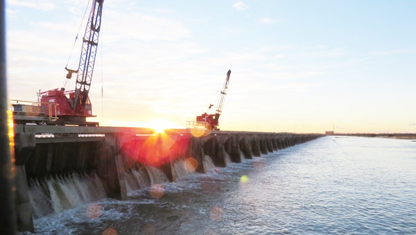
- Cranes atop the Bonnet Carre Spillway pull the wooden pins Jan. 10 to open the bays allowing the Mississippi River to flow through. It was the 11th time the Spillway was opened to divert flood water to Lake Pontchartrain. (Lori Lyons/L’OBSERVATEUR)
NORCO — It was 1927. The Harlem Globetrotters had their basketball debut, the first transatlantic phone call was made from New York City to London, and Charles Lindbergh was preparing for his famed solo, non-stop flight across the Atlantic.

Construction of the Bonnet Carre Spillway began in 1929.
It was also the year of the most destructive river flood in the history of the United States.
Louisiana was one of seven states impacted by the Great Flood of 1927.
The Mississippi River rushed through more than 200 crevasses of the levees along its banks.
The water inundated approximately 26,000 square miles of land, left an estimated 700,000 people homeless and 500 people dead.
The flood also forced the Mississippi River Commission to rethink its previous “levees only” plan of flood prevention.
With the passage of the Flood Control Act of 1928, the U.S. Army Corps of Engineers explored alternate approaches to flood control, including a spillway to divert flood water from the river to Lake Pontchartrain, Lake Borgne and, eventually, the Gulf of Mexico.
Initially, the Corps of Engineers considered building the spillway at the site of the Bonnet Carré crevasse in St. John Parish, where the levee had last been repaired in 1883.
Upon further inspection, the ability of the poor foundation there to support the massive concrete structure was questioned.
The location of the project moved a few miles downriver to St. Charles Parish.
Construction of the Bonnet Carré Spillway began in 1929 and was completed in two and a half years.
The 350-bay structure, comprised of high-strength concrete mixed specifically for the project, holds 7,000 vertical timbers in place against the river’s water.
It is listed on the National Register of Historic Places.
Also listed is the Kugler and Kenner Cemeteries Archeological District, two African-American cemetery plots located near the spillway structure.
The cemeteries, along with four plantations and several homes, were bought by the government for the spillway.
The spillway was first used for flood control in 1937 and among the many people who viewed the area that year was President Franklin D. Roosevelt.
“My dad was driving to Loyola at the time,” LaPlace native Gerard Montz said. “I remember him telling me that he saw the President traveling in his motorcade heading to the spillway.”
When not rerouting river water to the lake, the spillway is used recreationally for many activities, including fishing, hunting, boating, dog training, flying hobby airplanes, picnicking, wildlife viewing and even making movies.
“We host two to three film events each year,” said Dr. Chris Brantley, project manager of the spillway. “Between 350,000 to 400,000 people annually visit the spillway.”
The spillway was opened Jan. 10 for the 11th time and closing began Monday.
“Closing of the spillway will likely take seven to 10 days, depending on river levels,” said. “As soon as the structure is closed and water begins to recede, our staff will begin preparations to have the structure ready for the next high water event, whether it’s this spring or in the future.”
By Ronny Michel